


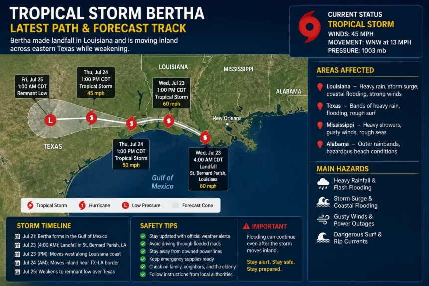
Tropical Storm Bertha Latest Path
Tropical Storm Bertha became one of the most closely monitored storms of the 2026 Atlantic hurricane season after forming in the Gulf of Mexico and moving toward the northern Gulf Coast. Although Bertha never reached hurricane strength, it still brought heavy rainfall, coastal flooding, strong winds, and dangerous surf across several states.
The latest forecast shows that Bertha made landfall in St. Bernard Parish, Louisiana, before tracking westward along the Louisiana coastline and then moving inland near the Texas-Louisiana border. Meteorologists expect the storm to continue weakening as it travels farther inland over Texas. (Reuters)
Residents across Louisiana and Texas should continue monitoring local weather advisories because flooding and heavy rainfall can persist even after tropical storm winds weaken.
Tropical Storm Bertha’s Latest Path
According to the latest updates from the National Hurricane Center (NHC), Bertha followed an unusual path compared to many Gulf tropical systems.
The storm initially developed over the northeastern Gulf of Mexico before drifting toward the central Gulf Coast. It strengthened into a tropical storm with sustained winds reaching approximately 60 mph (95 km/h) before gradually weakening because of strong wind shear and less favorable atmospheric conditions. (Houston Chronicle)
Its forecast track included:
- Formation in the Gulf of Mexico
- Slow movement toward the northern Gulf Coast
- Landfall in southeastern Louisiana
- Westward movement along coastal Louisiana
- Inland movement near the Texas-Louisiana border
- Continued weakening across eastern Texas
Forecasters emphasized that while Bertha’s wind speeds were moderate, the storm’s greatest threat came from prolonged heavy rainfall and localized flash flooding.
Where Is Tropical Storm Bertha Now?
The latest advisory indicates that Bertha moved inland near the Texas-Louisiana border after making landfall in Louisiana. Maximum sustained winds decreased to around 45 mph (75 km/h), and forecasters expected continued weakening until the system dissipates. (Investing.com)
Although tropical storm-force winds gradually weakened after landfall, several hazards remained:
- Heavy rainfall
- Flash flooding
- Coastal flooding
- Gusty winds
- Dangerous rip currents
Even weakening tropical systems can continue producing flooding long after their strongest winds disappear.
States Affected by Tropical Storm Bertha
Several Gulf Coast states experienced impacts from Bertha.
Louisiana
Louisiana received some of the storm’s strongest impacts, including:
- Heavy rain
- Coastal flooding
- Strong wind gusts
- Storm surge in low-lying areas
Communities near New Orleans and southeastern Louisiana experienced periods of intense rainfall as the storm passed nearby. (Reuters)
Texas
As Bertha tracked westward, eastern Texas began receiving:
- Bands of heavy rain
- Localized flooding
- Wind gusts
- Rough surf along the coastline
Meteorologists warned that rainfall totals could continue increasing even after the storm weakened inland. (Reuters)
Mississippi and Alabama
Although Bertha did not make landfall in these states, outer rainbands produced:
- Heavy showers
- Gusty winds
- Rough seas
- Dangerous beach conditions
Residents were advised to avoid unnecessary travel during periods of intense rainfall.
Wind Speed and Storm Strength
One reason Bertha attracted attention was its changing intensity throughout its life cycle.
During its strongest phase, Bertha produced sustained winds near 60 mph (95 km/h) before weakening because of persistent wind shear over the Gulf. After landfall, maximum sustained winds dropped to approximately 45 mph (75 km/h) and continued decreasing as the storm moved inland. (Investing.com)
Despite remaining below hurricane strength, these winds were still capable of:
- Downing small trees
- Damaging power lines
- Producing scattered power outages
- Causing minor structural damage
- Creating hazardous driving conditions
Weather experts often remind residents that flooding—not wind—is responsible for many tropical storm fatalities.
Why Bertha Weakened
Many people expected Bertha to strengthen into a hurricane because Gulf waters were relatively warm. However, several atmospheric conditions prevented rapid intensification.
Forecasters pointed to:
- Strong vertical wind shear
- Dry air intrusion
- Limited time over open water
- Disorganized thunderstorm activity
These factors disrupted the storm’s circulation and prevented it from developing into a stronger hurricane before landfall. (Houston Chronicl
Heavy Rainfall and Flooding Threat
While Tropical Storm Bertha’s winds weakened after landfall, meteorologists warned that the storm’s greatest danger shifted to excessive rainfall. Tropical systems often continue producing heavy rain for many hours after moving inland, increasing the risk of flash flooding, especially in low-lying communities and urban areas.
Forecast models indicated that portions of southeastern Louisiana and eastern Texas could receive several inches of rain in a short period. Slow-moving rainbands repeatedly passed over the same locations, making flooding more likely. Areas with poor drainage, small streams, and rivers were considered particularly vulnerable.
Residents were advised to avoid driving through flooded roadways. Even shallow water can hide damaged pavement or strong currents capable of sweeping vehicles away. Emergency officials continued monitoring rivers and bayous for rising water levels as Bertha’s remnants moved inland. (reuters.com)
Coastal Flooding and Storm Surge
Although Bertha remained below hurricane strength, it still generated storm surge along parts of the Louisiana coastline. Storm surge occurs when strong winds push seawater onto normally dry land, causing flooding in coastal neighborhoods.
Communities located near bays, marshes, and low-lying coastal roads experienced the greatest impacts. Combined with high tides and large waves, coastal flooding affected transportation and temporarily closed some roads.
Emergency managers encouraged residents living in flood-prone areas to stay informed through local weather alerts and follow any evacuation guidance if conditions worsened. The risk of dangerous rip currents also remained high along Gulf Coast beaches, making swimming unsafe even after the storm center moved inland.
Travel Disruptions Across the Gulf Coast
Bertha caused disruptions to transportation throughout the affected region. Heavy rain reduced visibility for drivers, while flooded streets and standing water created hazardous travel conditions.
Some airports experienced flight delays because of thunderstorms, strong wind gusts, and poor visibility. Travelers were encouraged to check directly with airlines before heading to the airport.
Marine traffic also faced challenges. Small boats were advised to remain in port until weather conditions improved, as rough seas and strong currents created dangerous conditions across the Gulf of Mexico.
Drivers traveling through Louisiana and eastern Texas were urged to allow extra travel time and avoid flooded highways whenever possible.
Power Outages and Infrastructure Impacts
Strong wind gusts and saturated ground increased the likelihood of falling trees and damaged power lines. Although Bertha was not a hurricane, tropical storm-force winds were still capable of causing scattered power outages.
Utility crews prepared in advance by staging repair teams throughout the Gulf Coast region. Following the storm, restoration efforts focused on repairing damaged electrical infrastructure, clearing debris, and restoring essential services.
Local governments also monitored drainage systems, bridges, and roadways for any storm-related damage. Emergency response teams remained ready to assist communities affected by flooding or fallen trees.
Emergency Response Efforts
State and local emergency agencies worked closely with the National Weather Service and the National Hurricane Center to provide timely updates throughout Bertha’s passage.
Officials emphasized several important safety recommendations:
- Stay indoors during severe weather.
- Monitor official weather forecasts regularly.
- Avoid flooded roads and bridges.
- Prepare emergency supplies, including drinking water, food, flashlights, batteries, and medications.
- Keep mobile devices fully charged in case of power outages.
These precautions helped reduce risks as heavy rainfall continued across parts of Louisiana and Texas.
Forecast After Landfall
Once Bertha moved inland, forecasters expected the system to weaken steadily because tropical storms rely on warm ocean water to maintain their strength.
The latest forecast projected:
- Continued weakening over eastern Texas.
- Heavy rain gradually decreasing over the next day.
- Flooding remaining possible even after winds diminished.
- The system eventually dissipating into a remnant low-pressure area.
Although Bertha’s circulation weakened, meteorologists reminded residents that post-landfall flooding often remains one of the most significant hazards associated with tropical systems. (reuters.com)
How Tropical Storms Are Tracked
Modern forecasting technology plays a vital role in monitoring tropical storms like Bertha. Meteorologists use multiple tools to track a storm’s development and predict its future path, including:
- Weather satellites that provide continuous images of cloud patterns.
- Hurricane hunter aircraft that fly into storms to measure wind speed, air pressure, and temperature.
- Ocean buoys that collect information on sea conditions.
- Doppler radar systems that monitor rainfall intensity and storm movement near land.
- Advanced computer forecast models that estimate future storm tracks.
These technologies help emergency officials issue timely warnings and improve public safety before, during, and after tropical storms.
Recovery Efforts After Tropical Storm Bertha
As Tropical Storm Bertha weakened and moved farther inland, recovery operations began across the affected Gulf Coast communities. Emergency crews assessed flooded neighborhoods, cleared fallen trees, restored power lines, and reopened blocked roads.
Local authorities encouraged residents to remain cautious, as hazards can persist even after a tropical storm has passed. Floodwaters may contain debris, contaminants, or hidden dangers, making it unsafe to walk or drive through standing water.
Utility companies worked around the clock to restore electricity to homes and businesses affected by scattered power outages. Public works departments also inspected bridges, drainage systems, and public infrastructure to ensure they remained safe for use.
Residents were advised to report damaged power lines, avoid unnecessary travel, and follow instructions from local emergency management officials until all hazards had been cleared.
Safety Tips After a Tropical Storm
Although Bertha weakened after landfall, safety remained a priority for everyone in affected areas. Weather experts recommend following these post-storm precautions:
1. Stay Updated
Continue monitoring official weather forecasts and emergency alerts because flood warnings may remain in effect even after the storm has weakened.
2. Avoid Floodwater
Never drive or walk through flooded roads. Floodwaters can be deeper than they appear and may contain strong currents capable of sweeping away vehicles.
3. Watch for Downed Power Lines
Stay away from damaged electrical lines and immediately report them to local utility providers.
4. Use Generators Safely
If using a portable generator during a power outage, keep it outdoors and away from doors and windows to prevent carbon monoxide poisoning.
5. Check on Family and Neighbors
Older adults, young children, and people with medical conditions may need additional assistance following severe weather.
Could Bertha Regain Strength?
Once Tropical Storm Bertha moved inland, meteorologists stated that it was not expected to regain tropical storm strength. Tropical cyclones require warm ocean water to maintain their circulation, and moving over land quickly weakens the system.
Although the storm itself continued to lose strength, its remnants were still capable of producing:
- Heavy rainfall
- Localized flooding
- Gusty winds
- Isolated thunderstorms
These impacts often continue for many hours after landfall, which is why emergency officials urged residents to remain alert.
2026 Atlantic Hurricane Season
Bertha serves as another reminder that even tropical storms can produce dangerous weather. The Atlantic hurricane season officially runs from June 1 through November 30, with activity typically increasing during August and September.
Meteorologists encourage residents in hurricane-prone regions to prepare before storms develop by:
- Creating an emergency plan
- Preparing an evacuation route
- Keeping emergency supplies ready
- Monitoring weather forecasts regularly
- Maintaining emergency contact information
Preparation before a storm forms can significantly reduce risks during severe weather events.
Frequently Asked Questions (FAQs)
What is the latest path of Tropical Storm Bertha?
The latest reports indicate that Bertha moved inland after making landfall in southeastern Louisiana and continued toward eastern Texas while steadily weakening.
Did Tropical Storm Bertha become a hurricane?
No. Bertha remained a tropical storm and weakened before it could intensify into a hurricane.
Which states were affected?
The storm primarily affected:
- Louisiana
- Texas
- Mississippi
- Alabama
These areas experienced varying levels of heavy rainfall, gusty winds, coastal flooding, and dangerous surf conditions.
What was Bertha’s biggest threat?
The greatest threats included:
- Flash flooding
- Heavy rainfall
- Coastal flooding
- Dangerous rip currents
- Isolated power outages
Flooding remained the most significant hazard after landfall.
Is Tropical Storm Bertha still active?
The latest forecasts indicated that Bertha weakened after moving inland and was expected to dissipate as it traveled farther across eastern Texas.
Conclusion
Tropical Storm Bertha may not have reached hurricane strength, but it demonstrated that tropical storms can still create widespread disruptions through heavy rainfall, flooding, storm surge, and gusty winds. After making landfall in southeastern Louisiana, the storm tracked westward and then moved inland near the Texas–Louisiana border, where it gradually weakened.
For residents across the Gulf Coast, the event highlights the importance of staying informed through official weather forecasts and taking preparedness measures before tropical systems arrive. Even after the strongest winds subside, flooding and hazardous conditions can continue to pose risks for several days.
As the 2026 Atlantic hurricane season continues, individuals living in coastal communities should maintain emergency plans, monitor forecasts regularly, and follow guidance from local authorities whenever tropical weather threatens.